

Unique Content | Attract Attention | Licensed | High Quality
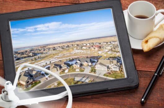

Aerial/Drone Photography
Listing Marketing Pros’ cutting-edge Aerial/Drone Real Estate Photography service! Elevate your property listings to new heights with our expert team of FAA Licensed drone pilots. Since 2019, we’ve been soaring above the competition, capturing breathtaking aerial views that will make your listings truly stand out.

Aerial/Drone Photography
Listing Presentation Flyer
Download and print out this FREE listing presentation flyer to include in your next listing presentation. This flyer will tell potential sellers about drone photography and answer a few FAQ’s. Showing potential sellers you use a Trusted Partner for your real estate photography and set yourself apart from the competition!
Don’t Just Settle For Standard Angles When Marketing Your Property.
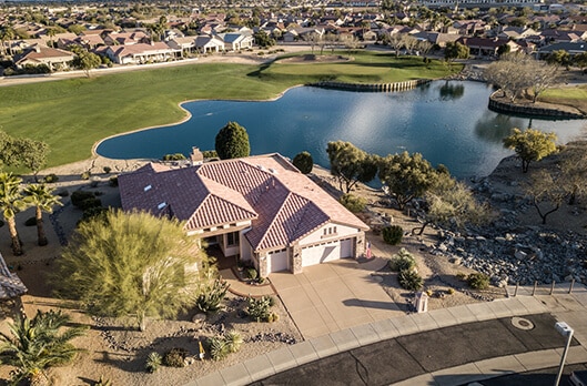
A Totally New Perspective
Every property has unique features waiting to be discovered. Our drones navigate the skies to capture high quality aerial photography that captures the essence of your listings with unparalleled precision. Showcase sprawling gardens, scenic views, and architectural brilliance like never before. From landscapes to neighborhoods, potential buyers get an immersive experience that goes beyond the confines of traditional marketing.


More Accurate Storytelling
Why just tell buyers about amenities when you can show them? Our Aerial Drone Photography transforms the way you present amenities. From exclusive golf courses to resort-style pools, let potential buyers explore the luxurious features of your listings from a bird’s-eye view. Create a visual narrative that resonates with their desires and aspirations with Listing Marketing Pros Aerial/Drone Photography.Stand Out and Sell Faster
In a competitive real estate market, standing out is not an option – it’s a necessity. Aerial Drone Photography is your secret weapon. Capture potential buyers attention with captivating visuals that leave a lasting impression. Position yourself as a trendsetter, showcasing listings with a level of sophistication that captivates and compels. Aerial photos make a massive difference when it comes to buying/selling residential property. It’s no surprise that 83% of sellers prefer to work with agents that use drones since aerial photography is proven to help homes sell 68% faster than those with just standard images.
Aerial Photography can give potential buyers and customers a complete view of the property and surrounding areas.

What to Expect
When your Aerial Photographer arrives at the property, they will want to walk the property to assess for any hazards or obstacles. Once they have walked the property and completed their assessment, the Aerial Photographer will then begin getting ready for take-off. At this point, please make sure everyone at the property remains inside while they are flying the property. This is to ensure that your Aerial Photographer is able to focus on the flight and any obstacles in the area with minimized distractions.
At Listing Marketing Pros we take the highest pride in our aerial photography and the equipment we use. All of our equipment is routinely maintained, pilots are FAA Licensed, and each flight is insured.
The Difference With us
Non-Licensed sUAS Pilot
A Non-Licensed sUAS Pilot has not passed the Licensing exam and is not allowed to legally charge for their services. Thus putting anyone that uses them along with the pilot at the risk of being assessed fines and penalties.
Licensed sUAS Pilot
An FAA Licensed Drone (sUAS) pilot has obtained the necessary knowledge and Licensing to operate under Part 107 Regulations from the FAA in order to operate a drone for commercial operations in the U.S.A. The test that is given covers a wide variety of questions from weather, sectional charts, airspace, temporary flight restrictions and more. Those that have completed this are allowed to legally charge for their services.
NOTE: The PIC (Pilot In Control) has the final decision after assessing weather, hazards, obstacles, and FAA At space requirements to determine if the flight is safe or not. The PIC has the full authority to shoot a property at any time during the scheduled day without prior notice based on assessing weather, hazards, obstacles, and FAA air space requirements and has full authority to terminate the flight at any time for any reason. Should this occur we will return to the property at a later date to complete the order. No refunds will be given We provide Aerial Photography for Businesses, Real Estate Listings and More. Servicing Surprise, Buckeye, Peoria, Glendale, Goodyear, Scottsdale, Anthem, and Phoenix and surrounding areas in Arizona
Flight decisions
The PIC (Pilot In Control) has the final decision after assessing weather, hazards, obstacles, and FAA air space requirements to determine if the flight is safe or not. The PIC has the full authority to shoot a property at any time during the scheduled day without prior notice based on assessing weather, hazards, obstacles, and FAA air space requirements and has full authority to terminate the flight at any time for any reason. Should this occur we will return to the property at a later date to complete the order. No refunds or credits will be given.

Weather
We will make every attempt to fly on the day of your scheduled appointment. Sometimes mother nature doesn’t always cooperate with us. When this happens, we will contact you ahead of time if possible, to reschedule the shoot. Should the Pilot In Control be enroute or arrive at the property and the weather conditions are not adequate to fly in a safe manner, we will contact you to reschedule.
Request More Information!

